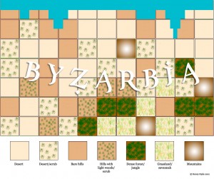
At the same time as I’m finishing the account of last year’s Grenouissian Intermezzo campaign and games, it’s time for me to get started on this year’s foray which features the mysterious colony of Byzarbia.
The idea of Byzarbia first came to me many, many years ago, when my chum Guy Hancock and I were dabbling in WRG 5th Edition Ancients at the same time as we were campaigning regularly with our eighteenth-century armies in The Wars of the Faltenian Succession. Quite simply, I had a Thematic Byzantine army and he had Arabs — what better way, I thought, could there be to create an instant colonial opposition than to combine these forces? As for naming them, well, Byzantium + Arabia = Byzarbia!
I actually made some sketch maps that indicated a long sea coast to the north, primarily desert terrain in the north and centre, with indications of a more humid and forested terrain to the south and south-east, but I had never taken it further than that. Well, now’s the time to complete the picture, and what you see below are the efforts of the last 24 hours.
You will already be familiar with my starting point for creating maps, as described in articles elsewhere on this blog relating to The Wars of the Faltenian Succession and The Grenouissian Intermezzo and, of course, in Battlegames magazine issues 1-12. In the Old School Extras section here, you will find an entry under “Creating Fictitious Maps” that refers to an ingenious web page created by Jonathan Broadus, where he has cleverly taken the basic formula based on dice rolls that I described in my articles and turned it into an automated system. Brilliant!
Quite simply, you enter the dimensions of the map you want to create and then click away. The system presents you with a randomly-generated map, consisting of squares indicating the general type of terrain that is most prevalent in each square. Remember, each of these squares is 50 miles across (you could, of course, adjust this to suit your own preferences), so we are dealing in general terms here, rather than details.
The other thing is that you don’t have to take what the system produces as gospel; if you feel that a square here or a square there needs to be tweaked to produce a more naturalistic geographic progression, then go right ahead – I have! Secondly, adjust the basic terrain types to suit your location on your imaginary globe. In my case, open ground has become desert; light woods have become desert and scrub; wooded hills have become hills with scrub or light woods; heavy woods have become dense forest or jungle; and I have converted some of the open ground to grassland or savannah. My intention is to produce a more ‘African’ than ‘European’ feel.
You can see the results of my deliberations below. More detailed mapping will follow in the weeks to come.


Be the first to comment